


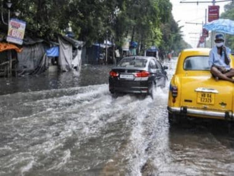
The Weather Report: Rains may ruin Durga Puja spirit in Bengal; wet week in north India likely
The Weather Report: Rains may ruin Durga Puja spirit in Bengal; wet week in north India likely
The four-month-long rainy season came to an end on 30 September as Indian Meteorological Department’s seasonal terminology considers June to September as “South West Monsoon”, October to December counts as “North East Monsoon” as rains dedicatedly shifts south India.
The season concluded on a positive note by receiving 106 per cent of LPA and became the fourth successive good monsoon on a pan-India level.
Data-wise overview and summary of the south west monsoon 2022:
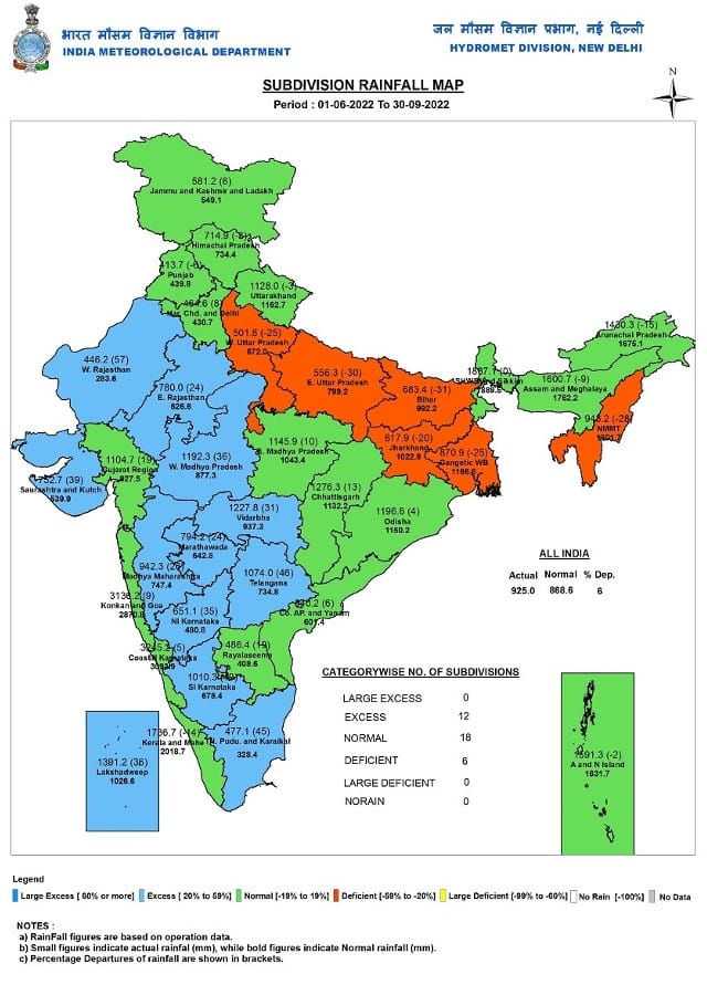
• Between 1 June till 30 September India as a whole recorded a total of 925.0mm rainfall against the average of 868.6mm with a departure of normal by +6.49 per cent.
Subdivision-wise seasonal rainfall figures
• Southern Peninsula: Actual 876.1mm against the average of 716.2mm, +22 per cent departure from normal.
• East & North East India: Actual 1124.8mm against the average of 1367.3mm, -18 per cent departure from normal.
• North West India: Actual 594.3mm against the average of 587.6mm, +1 per cent departure from normal.
• Central India: Actual 1161.1mm against the average of 978.0mm, +19 per cent departure from normal.
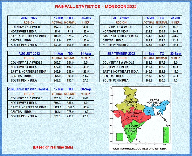
At 327.7mm the country observed the highest rainfall in the month of July wherein the least rainfall was recorded in the month of June with 152.3mm and a departure of -8 per cent from normal.
Subdivision wise June was wettest for East and North East India as the region experienced 400.9mm rains, July was wettest for central India southern peninsula and North West India with 458.7mm, 328.1mm and 232.3mm respectively.
Out of the total 36 meteorological subdivisions, 12 subdivisions constituting 40 per cent of the total area of the country received excess, 18 subdivisions (43 per cent of the total area) received normal rainfall and 6 subdivisions (17 per cent of the total area) received deficient seasonal rainfall. These six Met subdivisions which got deficient rainfall are West Uttar Pradesh, East Uttar Pradesh, Bihar, Jharkhand, Gangetic West Bengal, and Nagaland, Manipur, Mizoram and Tripura (NMMT). Out of these six subdivisions, the majority of them lie in the Gangetic Plains.
Total seasonal rainfall in India’s major 28 cities in descending order
Mangalore — 3483 mm
Valparai — 3441 mm
Mumbai — 2658 mm
Coochbehar — 2246 mm
Kochi — 1371 mm
Bhubaneswar — 1166 mm
Bangalore — 1066 mm
Kodaikanal — 1023 mm
Kolkata — 905 mm
Ahmedabad — 844 mm
Mysore — 814 mm
Hyderabad — 731 mm
Machilipatnam — 686 mm
Patna — 663 mm
Tirupathi — 650 mm
Vellore — 569 mm
Salem — 538 mm
Delhi — 516 mm
Madurai — 502 mm
Chennai — 498 mm
Trichy — 484 mm
Vizag — 447 mm
Kavali — 439 mm
Cuddalore — 384 mm
Coimbatore — 235 mm
Kanyakumari — 197 mm
Churu — 134 mm
Tuticorin — 53 mm
There were six Monsoon Depressions formed during the season; out of that, one system intensified into Deep Depression during 19-23 August. Out of six Depressions, four systems formed in August, one in July and one in September.
The number of low pressure system days was 67 during the season against the normal of 57 days.
Over the past week rains have decreased significantly across India as mainly dry weather is observed across the North India, Central, West, East and North East India continue to experience scattered showers but with a reduced intensity.
Only Telangana, Andhra Pradesh and Tamil Nadu saw increased rains in the past week.
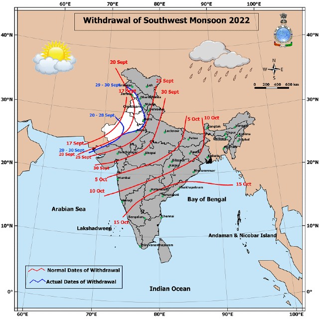
Due to prevailing dry weather for more than five days and reduction in moisture content, the Indian Meteorological Department declared the withdrawal of the southwest monsoon from most parts of Jammu, Kashmir, Punjab, Haryana, Delhi NCR and West Rajasthan.
Current synoptic features influencing weather in India as on 2nd October:
• The withdrawal line of Southwest Monsoon continues to pass through Jammu, Una, Chandigarh, Karnal, Baghpat, Delhi, Alwar, Jodhpur and Nalia.
• The cyclonic circulation over West Central Bay of Bengal off Andhra Pradesh coast extending up to 5.8 km above mean sea level tilting southwestward with height persists.
• The feeble Western Disturbance as a trough now runs roughly along 70°E to north of 30°N with its axis at 3.1 km above mean sea level.
• A cyclonic circulation is likely to emerge into the northeast and adjoining east central Bay of Bengal during next 24 hours.
All India Weather Forecast till 8 October:
North India
The dry weather is all set to end and once again monsoon to bounce back in North India across the next week.
The remnant of the Cyclone Noru to re-emerge in the Bay of Bengal on 2 October as a low pressure area and expected to move across Central India and reach up to north India by 5-6 October and interact with an approaching Western Disturbance trough around West Uttar Pradesh.
Under such weather phenomenon, easterlies will make a comeback over the plains of North India by 4 October.
In the period of 4 to 8 October widespread impact is expected across Uttar Pradesh and Uttarakhand as very heavy to extremely heavy rains are very likely in both the states. This may lead to cloudbursts, landslides and flash flood-like situations in the hills of East Uttarakhand and Nepal. Similarly, the rivers in Uttar Pradesh may swell water by the next week and flood risks are on the higher side.
The outer periphery clouds from the Western Disturbance and low pressure area interaction will bring another spell of light to moderate rains in Delhi NCR, East Haryana, Himachal Pradesh, East Rajasthan and East Punjab from the evening of 5 October till 8 October.
Expected precipitation accumulation till 8 October:
• Uttar Pradesh: 180mm
• Uttarakhand: 160mm
• Himachal Pradesh: 40mm
• Delhi NCR: 40mm
• Haryana: 30mm
• Punjab: 20mm
• Rajasthan: 10mm
Central India
Monsoon rains are all set to revive over central parts of the country as Bay to Bengal spins another low pressure area towards Chhattisgarh and Madhya Pradesh.
As per the initial Indications Widespread moderate to heavy rains will make a comeback over Chhattisgarh, Madhya Pradesh during 3 to 7 October.
Parts of Maharashtra to experience scattered light to moderate rains in this period and Gujarat to observe mainly dry weather considering that the low pressure will recurve towards North India due the interaction with the western disturbance and further west movement towards Gujarat will be restricted.
Expected precipitation accumulation till 8 October:
• Chhattisgarh: 90mm
• Madhya Pradesh: 50mm
• Maharashtra: 30mm
• Gujarat: 1mm
East and North East India
Under the influence of the low pressure area in the Bay of Bengal and moisture incursion of the southerly winds from the sea will bring an active phase of monsoon in the country’s east and North East across the next week.
Moderate to heavy rains are expected across Bihar, Jharkhand, Odisha, and West Bengal from 3 to 6 October, also some places may observe very heavy rains and Durga Puja celebrations might get impacted due to incessant rains.
After nearly three months of inactivity conditions are becoming favourable for a good revival of monsoon in North East India over the next week, most parts in Arunachal Pradesh, Assam, Meghalaya, Mizoram, Nagaland, Tripura, Manipur and Sikkim to experience heavy to very heavy rains during next week till 8 October, places near to the Himalayas are bound to receive heavy precipitation in this period.
Expected precipitation accumulation till 8 October:
• North East India: 140mm
• Odisha: 80mm
• West Bengal: 80mm
• Jharkhand: 70mm
• Bihar: 60mm
Southern Peninsula
In the past week good rains were observed in most parts of Telangana, Andhra Pradesh and Tamil Nadu leading to an overall comeback to monsoon in south India.
Also this week conditions will remain suitable for heavy to very heavy rains in Andhra Pradesh specially in the coastal parts, light to moderate rains are also likely to continue in many parts of Telangana and Tamilnadu.
Pull effect to be observed around the west coast due to the formation of Low pressure area in Bay of Bengal – it will help in strengthening of the off-shore trough it will result in good rains over Coastal and Ghats of Kerala, Karnataka, Goa across this week till 8 October.
Expected precipitation accumulation till 8 October:
• Andhra Pradesh: 110mm
• Kerala: 900mm
• Telangana: 70mm
• Goa: 70mm
• Karnataka: 60mm
• Tamil Nadu: 40mm
The active spell of rains will stall the further withdrawal of the monsoon in northern and central parts of the country for another 10 days – for some states, this season may become one of the most delayed monsoon retreats as rains continue to keep a stronghold.
The author, better known as the Rohtak Weatherman, interprets and explains complex weather patterns. His impact-based forecasts @navdeepdahiya55 are very popular in north India.
Read all the Latest News, Trending News, Cricket News, Bollywood News,
India News and Entertainment News here. Follow us on Facebook, Twitter and Instagram.
What's Your Reaction?


