


The Weather Report: Himalayas set to welcome winter soon; North, Central and West India experiencing pleasant days
The Weather Report: Himalayas set to welcome winter soon; North, Central and West India experiencing pleasant days

October is coming to an end also weather in most parts of India is in seasonal transition phase.
Himalayas are all set to welcome winter very soon as temperatures are already dipping while plains of North India, Central India and West India are experiencing pleasant days and nights typical of autumn weather for these regions.
In the past week most parts of North, Central and West India observed dry and clear weather conditions as no major weather system had influenced these regions after the monsoon withdrawal took place.
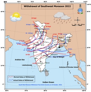
The South West Monsoon had withdrawn from the entire country on 22nd October, delayed by at least a week as the normal pan-India withdrawal date is 15th October.
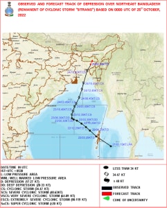
Bay of Bengal hosted first post monsoon Cyclone of the year name “Sitrang” in the past week which is very usual for this time of the year, on the day of Diwali i.e 24th October it made a landfall in Bangladesh hence India’s coastal areas remained unaffected in terms of direct impact.
Post Landfall in Bangladesh, cyclonic storm weakened gradually into a depression and influenced the weather across the North East India during the period of 23rd to 25th states observed heavy to extremely heavy rains in many parts and the country’s North East had to celebrate a wet Diwali this year.
On Record, Shillong received 196.7mm rainfall in the span of 24 hours ending 25th October at 8:30am, Highest One day Rainfall in October at least since 2011.
The All time record is 262.0mm from 8th October 2004.
Very Heavy to extremely heavy rains in stations of North East India on 25th October:
Mawphlang: 255.4mm
Pynursla: 253.0mm
WilliamNagar; 225.0mm
Cherrapunji; 223.0mm
Sect Hills (Shillong); 212.0mm
Lumingshai; 198.9mm
Shillong; 196.7mm
Barapani: 178.2mm
Mawkyrwat: 180.0mm
Nights have became significantly cooler in the plains of North India under the influence of the dry and cool Northwest winds blowing in the region:
Top 10 Coldest stations on 29th October, Saturday:
Sikar: 10.5°c
Fatehpur Shekhawati: 12.6°c
Bathinda: 12.6°c
Jalandhar: 12.8°c
Lakhimpur Kheri: 13.0°c
Adampur: 13.1°c
Ritholi: 13.1°c
Churu: 13.5°c
Moga: 13.6°c
Firozpur: 13.8°c
As soon as South West Monsoon withdrawn from peninsula autumn chill has commenced up to Karnataka and Telangana latitudes as minimum temperature has fallen significantly in the past week.
Belgaum in Karnataka recorded 12.4°c minimum temperature on the 24th October, Just missed all time record for lowest minimum temperature of the month which is 12.3°c from 27th October 2008.
Similarly Hyderabad recorded 14.9°c minimum temperature on the 24th October, marking the Lowest temperature in the month of October at least since 2011.
Indian Meteorological Department declared commencement of northeast Monsoon rainfall Under the influence of setting in of northeasterly winds in the lower tropospheric levels over Bay of Bengal and South Peninsular India, the Northeast Monsoon rains commenced over coastal Tamil Nadu, Pondicherry & Karaikal and adjoining areas of south coastal Andhra Pradesh on 29th October.
Weather conditions were largely dry in the past week but as soon as the North East Monsoon set in rains have increased significantly in the last 24 hours:
Tamil Nadu:
Cuddalore (dist Cuddalore): 80mm,
Puducherry (dist Puducherry): 70mm,
Cuddalore collectorate, Srimushnam (dist Cuddalore), Nanguneri (dist Tirunelveli): 60mm each,
Marakkanam (dist Villupuram): 50mm,
Vanur (dist Villupuram), Kurinjipadi (dist Cuddalore), Sethiathope (dist Cuddalore): 40mm each,
Virudhachalam (dist Cuddalore), Bhuvanagiri (dist Cuddalore), Agaram Seegur (dist Perambalur): 30mm each,
Neivasal Thenpathi (dist Thanjavur), Panruti (dist Cuddalore), Villupuram (dist Villupuram), Vedaranyam (dist Nagapattinam), Pelandurai (dist Cuddalore) , Vallam (dist
Thanjavur), Uthangarai (dist Krishnagiri): 20mm each,
Ulundurpet (dist Kallakurichi), Vepur (dist Cuddalore), Lalpet (dist Cuddalore) ,Labbaikudikadu (dist Perambalur), Thalaignayer (dist Nagapattinam), Radhapuram (dist Tirunelveli), Eraiyur (dist Perambalur) , Chidambaram (dist Cuddalore), Thirupathisaram Aws (dist Kanyakumari), Tambaram (dist Chengalpattu), Thirupoondi (dist Nagapattinam), K.m.koil (dist Cuddalore), Perambalur (dist Perambalur), Sendurai (dist Ariyalur), Mannargudi (dist Tiruvarur), Gingee (dist Villupuram) , Orthanad (dist Thanjavur): 10mm each.
Coastal Andhra Pradesh:
Sullurpeta (dist Spsr Nellore): 20mm, Gudur (dist Spsr Nellore): 10mm, Kavali (dist Spsr Nellore): 10mm, Venkatagiri (dist Spsr Nellore): 10mm, Udayagiri (dist Spsr Nellore): 10mm.
Rayalaseema:
Thottambedu (dist Chittoor): 30mm, Srikalahasti (dist Chittoor): 20mm, Tirupati Aero (dist Chittoor): 10mm, Kodur (dist Ysr District): 10mm, Kalakada (dist Chittoor): 10mm, Chinnamandem (dist Ysr District): 10mm
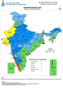
Rains performance in the post Monsoon season so far continues to stay in Large excess category across the country as India as whole recorded a total rainfall of 110.2mm against the normal of 72.7mm in the period of 1st to 29th October, the departure from normal stands at +52%.
Country wide areas falling in rainfall category:
Large excess: 38% area of India
Excess: 28% area of India
Normal: 23% area of India
Deficient: 2% area of India
Large Deficient: 9% area of India
No Rain: 0% area in India.
Subdivision wise seasonal rainfall figures
• Southern Peninsula: Actual 167.5mm against the average of 143.6mm, +17% departure from normal.
• East & North East India: Actual 164.0mm against the average of 120.8mm, +36% departure from normal.
• North West India: Actual 64.3mm against the average of 21.3mm, +202% departure from normal.
• Central India: Actual 93.2mm against the average of 55.6mm, +68% departure from normal.
Current synoptic features influencing the weather in India as on 29th October:
• Under the influence of setting in of northeasterly winds in the lower tropospheric levels over Bay of
Bengal and South Peninsular India, the Northeast Monsoon rains have commenced over coastal Tamil
Nadu, Pondicherry & Karaikal and adjoining areas of south Coastal Andhra Pradesh today, the 29th Oct
2022.
• The cyclonic circulation over Southwest Bay of Bengal and adjoining Sri Lanka at 1.5 km above
mean sea level persists.
• The cyclonic circulation over Southeast Bay of Bengal & adjoining Equatorial north Indian ocean
extending upto 1.5 km above mean sea level persists.
• A fresh Western Disturbance likely to affect Western Himalayan Region from the night of 31st October,
2022.
All India weather forecast till 5th November:
• North East Monsoon to take aggressive start in southern parts of India early next week as North East winds are expected to strengthen further.
Widespread moderate rainfall with fairly widespread heavy rains likely over Tamil Nadu, Coastal Andhra Pradesh, Rayalaseema, Coastal & South Interior Karnataka and Kerala during 31st October till 3rd November, some stations might experience very heavy rains in the period, also Chennai is set to experience very heavy rains and North East Monsoon will set in with a bang next week.
• Under the influence of fresh Western Disturbance, a round of scattered light to Moderate snowfall is expected over parts of Kashmir, Ladakh and Himachal Pradesh and some parts of Uttarakhand during the period of 31st October till 2nd November.
Plains to North India will remain unaffected by this Western Disturbance and weather conditions will continue to stay dry in Punjab, Haryana, Delhi, Rajasthan, Uttar Pradesh.
In a quick succession another western disturbance is expected to impact North West India around 5th November, this might bring some rains for plains, temperatures will start falling significantly from the second week of November.
States in Central and East India will observe dry weather conditions for the next week as no significant weather system affects the region.
Under the influence of dry and cool North West winds and clear skies during night, minimum temperature to fall further by 1-2°c in Bihar, Jharkhand, West Bengal, Odisha, Chhattisgarh, Madhya Pradesh, Gujarat, Maharashtra in the upcoming week, days to stay pleasant as well.
• States in North East India are out of impact from cyclone Sitrang and weather conditions have improved over the weekend, following the trend most states in the region to experience dry weather conditions with drop in night temperatures during the upcoming week till 5th November, chances of any significant rains due to the absence of any impactful weather system.
The author, better known as the Rohtak Weatherman, interprets and explains complex weather patterns. His impact-based forecasts @navdeepdahiya55 are very popular in north India.
Read all the Latest News, Trending News, Cricket News, Bollywood News,
India News and Entertainment News here. Follow us on Facebook, Twitter and Instagram.
What's Your Reaction?


