


The Weather Report: Monsoon set to withdraw from Central India; South, North to experience rains
The Weather Report: Monsoon set to withdraw from Central India; South, North to experience rains

The festival season has begun in India but monsoon is in no mood for a retreat.
It has been raining across the states of East and Central India during the Durga Puja and Dussehra and rains have progressed towards North India in the second half of the week.
The Indian Meteorological Department considers the South West Monsoon as seasonal rains from June to September only, rains in October are accounted for in the post-monsoon season also known as North East Monsoon in the parts of southern India.
The South West Monsoon has further withdrawn from parts of Rajasthan, Haryana, Punjab, West Uttar Pradesh and even Delhi but a low-pressure area has approached from the Bay of Bengal along with the interaction of trough brought extremely heavy rains in Uttar Pradesh during the last three days and a significant increase in rainfall is observed in Rajasthan, Haryana, Delhi NCR, East Gujarat and Mumbai on Saturday morning. The same low-pressure area was responsible for heavy rains across North East India, West Bengal, Bihar, Jharkhand, Chhattisgarh, Madhya Pradesh and Telangana earlier in the week.
Record-breaking rains in parts of Uttar Pradesh:
Bahraich recorded a total rainfall of 319.2mm so far in October. This is a new monthly all-time record breaking the previous record of 310.2mm from the year 1946.
Extremely heavy rains occurred in most parts of the foothills of Uttar Pradesh on 6 October:
Trimohani Ghat (Maharajganj) — 410mm
Gonda — 360mm
Ayodhya — 314mm
Chanderdeep Ghat (Gonda) — 298mm
Bhinga (Shrawasti) 230mm
Kushinagar — 210mm
Kakardhari (Bahraich) — 208mm
Elgin Bridge (Barabanki) — 204mm
Gorakhpur — 178mm
Mohammedpur (Gonda) — 177mm
Haidergarh (Barabanki) — 155mm
Heavy rains have made a comeback over Mumbai and parts of Maharashtra and Gujarat in the past three days.
Ending 8.30 am on 8 October, Santacruz recorded 114mm which is the highest 24 hours-span rainfall at least in the last 10 years for the month of October.
Heavy to very heavy rains in Mumbai metropolitan region ending 8:30 am on 8 October:
Versova:134mm
Andheri:109mm
Marine Lines:173mm
Byculla:181mm
Mahalaxmi:177mm
Sion:140mm
Bandra: 120mm
Vikhroli: 134mm
Heavy rains in National Capital Delhi ending 8.30 am on 9 October:
Lodhi Road — 87.2mm
Ayanagar — 85.2mm
Safdarjung — 84.3mm
Palam — 63.9mm
Ridge — 60.1mm
Post monsoon rains so far in Safdarjung had reached 99.9mm against the average of 7.9mm the departure from normal stands at +1165% above normal.
Also crossed the annual average rains, till 9 October recorded a total of 782mm, the Normal for the entire year is 758.9mm at the Safdarjung Observatory.
Consistent rains in the last 48 hours period have also led to a major drop in day temperatures around the region leading to overall cool weather in the plains of North India:
Maximum temperature (departure from normal) on 8 October:
Delhi Safdarjung — 23.4°c(-10°c)
Delhi Palam:23.7°c(-11°c)
Rohtak:23.4°c(-11)
Meerut:22.8c(-10°c)
Agra:24.3c°c(-11°c)
Aligarh:22.6°c(-11°c)
Bareilly:21.9°c(-11°c)
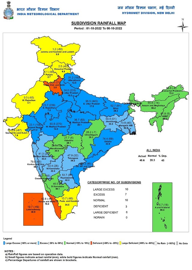
The performance of the post monsoon season so far is excess across the country as India as a whole recorded a total of 40.6mm against the normal of 28.3mm in the period of 1st to 8 October. the departure from normal stands at +43 per cent.
Subdivision-wise seasonal rainfall figures
• Southern Peninsula: Actual 50.6mm against the average of 45.7mm, +11 per cent departure from normal.
• East and North East India: Actual 60.6mm against the average of 52.9mm, +14 per cent departure from normal.
• North West India: Actual 22.7mm against the average of 7.8mm, +191 per cent departure from normal.
• Central India: Actual 41.5mm against the average of 25.2mm, +65 per cent departure from normal.
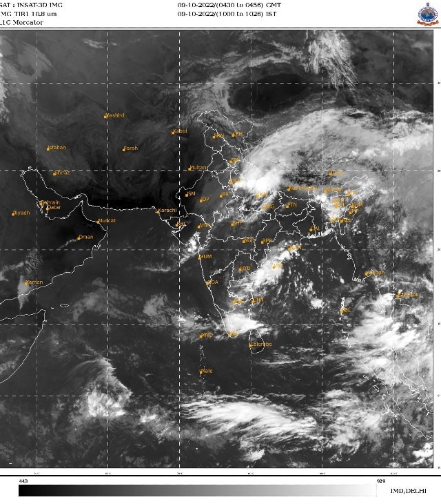
Current synoptic features influencing weather in India as on 9 October:
• The withdrawal line of Southwest Monsoon continues to pass through Long. 79.0 E/ Lat. 31.7 N Uttarkashi, Nazibabad, Agra, Gwalior, Ratlam and Bharuch.
• The Western Disturbance as a trough in mid and upper tropospheric westerlies with its axis at 5.8 km
above mean sea level now runs roughly along 75°E to the north of 32°N.
• The Western Disturbance as a trough in mid and upper tropospheric Westerlies with its axis at 5.8 km
above mean sea level now runs roughly along 68°E to the north of 32°N.
• The cyclonic circulation over Gujarat Region and neighbourhood now lies over southeast Rajasthan &
neighbourhood and extends upto 5.8 km above mean sea level.
• The trough from the above cyclonic circulation over southeast Rajasthan & neighbourhood to Punjab
across north Rajasthan and Haryana between 1.5 km & 3.1 km above mean sea level.
• The cyclonic circulation over central parts of south Bay of Bengal now lies over southwest Bay of
Bengal and neighbourhood and extends upto 5.8 km above mean sea level.
All India Weather Forecast till 15th October:
North India
The current spell of monsoon rains will continue to impact North India till Tuesday as recurving low pressure area to affect Uttar Pradesh and Uttarakhand with heavy to Very heavy rains during next two days. Also the Western Disturbance in the backend may bring more light to moderate rains in Punjab, Haryana, Himachal Pradesh, Jammu, Delhi NCR and northern Rajasthan during 10 to 12 October.
After 12 October cool and dry north west winds sweep across North India will lead to major decline in rainfall over the region and minimum temperatures to dip up to 15°c in rural areas of the plains, the first shot of Autumn morning chill is about to begin.
Expected precipitation accumulation till 15 October:
• Uttar Pradesh: 110mm
• Uttarakhand: 70mm
• Himachal Pradesh: 30mm
• Delhi NCR: 10mm
• Haryana: 10mm
• Punjab: 10mm
• Rajasthan: 5mm
Central India
After a decent monsoon revival of rains in the past week, it’s time to bid adieu the monsoon 2022 from central parts of the country, as soon as current spell of monsoon rains ends from North India anti-cyclonic circulation will start setting up over the Rajasthan and Gujarat it will push dry winds across the interiors of the country and restrict movement of any low-pressure areas in-land.
Under such conditions, monsoon will start withdrawing from most parts of North India and in quick succession, it will withdraw from most parts of Gujarat, Maharashtra, Madhya Pradesh and Chhattisgarh towards the end of this week, overall rains are also likely to be lesser till 15th October as no weather system will influence the conditions in Central India.
Expected precipitation accumulation till 15 October:
• Maharashtra: 30mm
• Chhattisgarh: 20mm
• Madhya Pradesh: 20mm
• Gujarat: 10mm
East and North East India
After an active fortnight in terms of monsoon rains, it is now time to switch to a dry mode in the eastern parts of the country.
In absence of any low-pressure area from the Bay of Bengal, rains are expected to decrease significantly in Bihar, Jharkhand, Odisha and West Bengal till 15 October but monsoon withdrawal is not likely as isolated rains will prevail in the region for another week.
Due to moist southern winds, parts of North East India will continue to host at least so kind of weather such as fairly widespread moderate rains and Isolated heavy rains in Arunachal Pradesh, Assam, Meghalaya, Mizoram, Nagaland, Tripura, Manipur and Sikkim to experience wet weather during next week till 15 October. Places near to the Himalayas are bound to receive very heavy precipitation in this period.
Expected Precipitation accumulation till 15 October:
• North East India: 110mm
• West Bengal: 30mm
• Odisha: 20mm
• Bihar: 20mm
• Jharkhand: 10mm
Southern Peninsula
Pre-North East Monsoon rains have commenced on most parts of Tamil Nadu and Andhra Pradesh in the past week, even Telangana, Karnataka and Kerala experienced some moderate rains till 8 October.
Under the influence of the cyclonic circulation off the east coast near Andhra Pradesh Easterlies will be gushing inland leading to an overall increase in rainfall across Tamil Nadu, Andhra Pradesh, Telangana and the interiors of Karnataka in the upcoming week, spells of moderate rains will be common with a possibility of heavy rains as well.
Parts of Kerala, Coastal Karnataka and Goa to observe reduction in rainfall till the end of the week.
As we progress towards mid-October eyes are on the formation of a low latitude weather system in the Bay of Bengal the sole reason of setting in of the North East Monsoon for Tamil Nadu and Andhra Pradesh but the confidence for such formation is low in weather models for the next week.
Expected Precipitation accumulation till 15 October:
• Tamil Nadu: 110mm
• Karnataka: 70mm
• Andhra Pradesh: 60mm
• Telangana: 50mm
• Kerala: 30mm
• Goa: 20mm
The author, better known as the Rohtak Weatherman, interprets and explains complex weather patterns. His impact-based forecasts @navdeepdahiya55 are very popular in north India.
Read all the Latest News, Trending News, Cricket News, Bollywood News,
India News and Entertainment News here. Follow us on Facebook, Twitter and Instagram.
What's Your Reaction?


