


Weather Report: Cyclone Mandous brings rains over North TN; North, East and North East India to remain dry this week
Weather Report: Cyclone Mandous brings rains over North TN; North, East and North East India to remain dry this week

Weather-wise India had a very happening week, Around this time usually the north-east Monsoon starts the wrap up for the season but spinning of a cyclone in the Bay of Bengal bring back the season to a new life as heavy rains and windy weather battered most parts of Tamil Nadu, Kerala, Karnataka, Andhra Pradesh over the weekend and the week closed on a wet note for the southern states of the country.
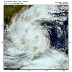
Cyclonic Storm Mandous was present off north Tamil Nadu and Puducherry coasts about 30 km southeast of Mamallapuram around 10:30PM on 9 December, the cloud spiral bands started entering into land areas of the coast and the Landfall process has commenced. It made a landfall over Mahabalipuram around the mid-night just 40 kilometres south of Chennai and the landfall process completed by the 3:30AM on the 10 December.
The cyclone brought very heavy to extremely heavy rains over most parts of north Tamil Nadu and Chennai along with wind gusts of 70 to 90km/h recorded at various weather stations, whereas other parts of Tamil Nadu experienced moderate to heavy rains and comparatively less wind speed.
Rainfall in the span of 48 hours ending 8:30AM on 10 December from stations in Chennai and neighbouring areas:
Ayanavaram: 201mm
Perambur: 200mm
Avadi: 200mm
Kattapakkam: 196mm
Kodambakkam: 189mm
Kanchi: 185mm
Alandur: 183mm
Malar Colony: 182mm
Tondiarpet: 179mm
TVK Nagar: 179mm
MGR Nagar: 178mm
Chennai: 177mm
Perungudi: 174mm
Under the influence of the cyclone Mandous various parts of Andhra Pradesh experienced very heavy to extremely heavy rains also resulted in flood-like conditions over some parts in the southern Andhra Pradesh.
Rainfall ending 8:30AM from various stations in the state of Andhra Pradesh:
Naidupets, Tirupati 281mm Hastha Kaveri, Tirupati: 242mm
Menubolu, Nellore 238mm Naidapet, Tirupati: 237mm
Ojui, Tirupati: 235mm
Bramhadevam, Nellore: 222mm
Venkatachalam, Nellore: 215mm
Srikalahaschi, Tirupati: 213mm
Sydapuram, Nellore 212mm Kota, Tirupati 211mm Thottambedu, Tirupati: 209mm
Chittedu, Tirupati 208mm Papavinasam Dam, Tirupati: 203mm
Valcadu Beach, Tirupati: 197mm
Chinthavaram, Tirupati: 193mm
BN Khandriga, Tirupati: 192mm
Nagari, Chittoor: 177mm
Venkatagiri, Tirupati: 189mm
Allur, Nellore: 107mm
Nellore Rural: 165mm
Vidavalur, Nellore: 160mm Doravarisatram, Tirupati: 150mm
Vadamal pets, Tirupati: 153mm
Tada, Tirupati: 101mm
Podalkur, Nellore: 136mm
Puttur, Tirupati: 123mm
Renigunta, Tirupati: 116mm
TirupTben: 110mm
Nellore Urban: 108mm
Rapur, Nellore: 81mm
Karedu, Nellore: 88mm
Chitvel, Annamayya: 74mm
Singarayakonds, Prakseam: 72mm
Chandragiri, Tirupati: 70mm
Weather in Central and West India was a seesaw between the haze and the bright sun. The week started with the haze and high air pollution levels in Maharashtra, Gujarat, Madhya Pradesh and Chhattisgarh, Major cities like Mumbai and Pune experienced poor air quality and Unusual thick layer of smog.
Despite begin a coastal metropolitan area Mumbai rarely experience smog layers which lasts for days but this time around slow wind speed, high moisture levels have provided sufficient time for the pollutants to penetrate in the atmosphere, the Meteorological conditions were favorable for the poor air quality index as winds were from north India was blocked due to the prevailing wind discontinuity in central India.
Later as the week progressed and formation of cyclone took place in the Bay of Bengal it sucked out all the moisture from the interior regions of the country towards the sea, dry winds from north India were blowing across the country and moisture levels have fallen considerably leading to a quick removal of smog across north, central and west India during the second half of the week.
We are almost approaching mid December but winter chill in north India is yet to be felt in the day time. Nights are cooler with day time minimum temperatures hovering around climatological normal but maximum temperatures are way above normal. On Sunday Delhi recorded 28.4°c maximum temperature registering 4°c above normal, similarly Chandigarh recorded 27.5°c, Lucknow 27.6°c, Jaipur 28.0°c all are 3 to 5°c above normal on 11 December.
The prevailing dry weather conditions in the absence of the western disturbance is the concern around the less cold winter so far, also if there is any western disturbance they are mainly restricted to upper Himalayas only.
A fresh moderate Western disturbance affected parts of Kashmir, Ladakh and North Himachal Pradesh during Thursday to Saturday brought good snowfall in region after a prolonged dry spell, famous hill station Sonamarg wrapped under thick blanket of snow as fresh 45cm of snowfall is recorded in the town during this spell, Gulmarg recorded 18cm whereas light snowfall occurred in Pahalgam, Shopian, Leh, Ladakh, Tanmarg.
Kargil experienced season’s first snowfall on 10 December accumulating at 5cm at the observatory on the town.
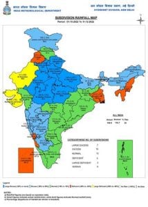
Rains in the southern parts of the country kept overall seasonal numbers in the above normal category for another week. Southern peninsula had a jump from -2% departure from normal during previous Sunday to +5% departure from normal on 11 December.
In the period of 1 October till 11 December, India received 136mm rainfall against the normal of 110.7mm, a departure from normal stands at +23%.
Subdivision wise seasonal rainfall figures:
• Southern Peninsula: Actual 271.5mm against the average of 258.4mm, +5% departure from normal.
• East & North East India: Actual 165.2mm against the average of 150.0mm, +10% departure from normal.
• North West India: Actual 80.6mm against the average of 37.0mm, +118% departure from normal.
• Central India: Actual 93.7mm against the average of 73.3mm, +28% departure from normal.
Current synoptic features influencing weather in India as on 11 December:
• The cyclonic circulation over north interior Tamil Nadu and adjoining South Interior Karnataka &
north Kerala extending up to 5.8 km above mean sea level persists. It is likely to emerge into Southeast
& adjoining East central Arabian Sea off north Kerala-Karnataka coast. Under its influence, a Low
Pressure Area is likely to form over the same region around 13th December and move west-
northwestwards away from the Indian coast thereafter.
•The Western Disturbance as a cyclonic circulation over north Pakistan & adjoining Punjab at 3.1 km
above mean sea level roughly along Long. 70°E to the north of Lat. 32°N persists.
• The other Western Disturbance as a trough in middle & upper tropospheric westerlies with its axis at
7.6 km above mean sea level now runs roughly along Long. 56°E to the north of Lat. 22°N.
• A cyclonic circulation likely to emerge into south Andaman Sea around 13th December, 2022.
All India Weather Forecast till 17 December:
South India:
The low pressure area in the Arabian sea will create pull effect features in the peninsula and this will lead to wet weather conditions across Goa, Karnataka, Kerala, Tamil Nadu and Andhra Pradesh till 13th December.
Heavy to Very heavy rains to occur in parts of Goa, West Karnataka and Kerala till Tuesday.
As soon as the low pressure area move West away from the west coast of India, Impact of rains will start decreasing Wednesday onwards and a relief from the wet weather will be on cards Thursday onwards and will last up to weekend.
Expected rainfall in South India till 17 December:
Tamil Nadu: 40mm
Andhra Pradesh: 40mm
Kerala: 70mm
Karnataka: 60mm
Telangana: 10mm
Goa: 40mm
Central India:
The prolonged spell of dry weather is all set to come to an end in the upcoming week, as the low pressure area has emerged in the Arabian sea off the west coast of India this is pushing moist southerly – easterlies winds in the states of central – west India, also wind discontinuity is taking shape on the lower levels – this developing instability in the atmosphere will bring wet spells in the states of Maharashtra, Madhya Pradesh, South Gujarat and parts of Chhattisgarh starting Monday onwards and it will last up to Thursday.
Major cities like Mumbai, Pune, Nagpur, Bhopal and Indore to start this week on a wet note.
Mostly cloudy weather and light to moderate rains are expected in the states, this will also results in fall in day temperatures and rise in minimum temperature across the region.
Maximum temperatures will be below normal in this week and rains are expected to be above normal.
The upcoming spell of rains is considered to be Unseasonable as rainfall events are very uncommon in central and western parts of the country around mid December.
Expected rainfall in central India till 17 December:
Maharashtra: 30mm
Madhya Pradesh: 20mm
Chhattisgarh: 10mm
Gujarat: 10mm
North, North East and East India:
The weather conditions over the North, East and North East parts of the country will remain dry across the upcoming week. Minimum and maximum temperatures will remain above normal in this period, the proper winter chill will be missing from these parts of the country for another week in the absence of western disturbance and wet weather.
Expected range of minimum and maximum temperature in the States till 17 December:
• Punjab: 4 to 10°c, 23 to 27°c.
• Haryana: 5 to 11°c, 23 to 28°c.
• Delhi NCR: 7 to 12°c, 24 to 28°c.
• Uttar Pradesh: 7 to 12°c, 25 to 30°c.
• Rajasthan: 3 to 13°c, 26 to 32°c.
• Chhattisgarh: 7 to 14°c, 27 to 33°c.
• Bihar: 7 to 12°c, 25 to 31°c.
• Jharkhand: 8 to 14°c, 27 to 32°c.
• West Bengal: 10 to 18°c, 28 to 34°c.
• Odisha: 9 to 15°c, 28 to 34°c.
• North East India: 3 to 14°c, 21 to 34°c.
The author, better known as the Rohtak Weatherman, interprets and explains complex weather patterns. His impact-based forecasts @navdeepdahiya55 are very popular in north India.
Read all the Latest News, Trending News, Cricket News, Bollywood News,
India News and Entertainment News here. Follow us on Facebook, Twitter and Instagram.
What's Your Reaction?


