


The Weather Report: Sunny and bright conditions to add cheers in Diwali; rains restricted to parts of peninsular India
The Weather Report: Sunny and bright conditions to add cheers in Diwali; rains restricted to parts of peninsular India

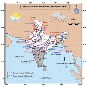
India is all set to celebrate festival of lights – Diwali – and weather is also cheerful with sunny and bright conditions over major parts of the country as monsoon has withdrawn from 60 per cent of the region.
Most parts of North, North East, East and Central India have experienced sunny and dry weather in the past week.
The rains have been restricted to parts of peninsular India as it rained across Pune, Mumbai, Bangalore, Kochi, Chennai, Hyderabad regularly in the past one week yet the North East Monsoon has not advanced into Tamil Nadu and Andhra Pradesh as some conditions are yet to be satisfied.
Winters are on the doorstep of the Himalayas as a fresh Western Disturbance brought snowfall at the hill stations of Kashmir, Ladakh and Himachal Pradesh on Thursday and Friday.
Season’s first snowfall recorded in the India meteorological department’s Observatories in Lahaul with Gondola at 3.0cm and Keylong 1.0cm till 8:30am on 21st October.
Rainfall at hill stations ending 8:30AM on 21st October:
Banihal 34.4mm
Bhaderwah 33.3mm
Qazi Gund 31.0mm
Dalhousie 23.0mm
Chamba 17.0mm
Kotkhai 13.1mm
Dharamshala 12.3mm
Post the western disturbance, clear skies lead to major drop in the minimum temperatures to the sub zero levels at various hill tops on 22nd October:
Hanle Top -7.7°c
Stakna -6.3°c
Drass -5.2°c
Leh -5.0°c
Padum -4.8°c
Chuchot -4.0°c
Gulmarg -2.4°c
Kargil -1.7°c
Kedarnath -1.5°c
Keylong -1.5°c
Baltal -1.5°c
Kukumsheri -1.4°c
Pahalgam -0.4°c
Meanwhile dry and pleasant weather persisted across the plains of North India, Central India and East India.
Parts of peninsula India continue to absorb some more rains before the monsoon says a final goodbye to the region.
Streak of evening thunderstorms in Pune lead it to cross 300mm rainfall mark for the month of October by recording a total of 303mm so far, this has been the 2nd wettest October in the past 11 years, 2020 was wettest in the decade with 312mm rainfall at the Shivajinagar observatory in the city.
Bangalore recorded the wettest year since the records were maintained by the Indian Meteorological.
City observatory recorded a total of 1801.2mm so far till 23rd October making it the all time high annual rainfall in the IT hub of the country.
Top 10 wettest years in Bengaluru since 1900:
2022 – 1801.2 mm
2017 – 1696.0 mm
2005 – 1608.5 mm
2021 – 1510.5 mm
1998 – 1431.8 mm
1916 – 1348.0 mm
1991 – 1338.5 mm
1903 – 1301.3 mm
2008 – 1286.0 mm
1958 – 1283.3 mm
Rains performance in the post Monsoon season so far is Large excess across the country as India as whole recorded a total of 104.2 against the normal of 63.2mm in the period of 1st to 23rd October, the departure from normal stands at +65%
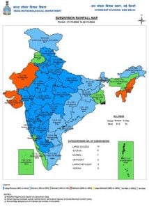
Subdivision wise seasonal rainfall figures
• Southern Peninsula: Actual 164.7mm against the average of 116.4mm, +41% departure from normal.
• East & North East India: Actual 129.5mm against the average of 109.2mm, +19% departure from normal.
• North West India: Actual 64.3mm against the average of 19.6mm, +228% departure from normal.
• Central India: Actual 93.2mm against the average of 50.0mm, +86% departure from normal.
Current synoptic features influencing the weather in India as on 23rd October:
• The Southwest Monsoon has withdrawn from the remaining parts of the country today, the 23rd
October, 2022.
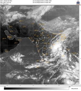
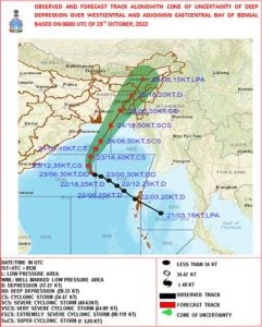
• The Deep Depression over east central Bay of Bengal moved northwestwards with a speed of 20
kmph during past 6 hours, and lay centered at 0830 hours IST of today, the 23rd October over the
west central & adjoining east central Bay of Bengal near latitude 15.6°N and longitude 88.4°E, about 640
km northwest of Port Blair, 670 km south of Sagar Island and 820 km south-southwest of Barisal
(Bangladesh). It is very likely to move northwestwards during next 12 hrs and intensify into a cyclonic
storm over central Bay of Bengal. Thereafter, it would recurve and move north-northeast wards and
cross Bangladesh coast between Tinkona Island and Sandwip close to Barisal around 25th October early
morning.
• The trough now runs from the cyclonic circulation associated with
the Deep Depression over west central & adjoining east central Bay of Bengal to Comorin area across
South Bay of Bengal & north Sri Lanka and extends upto 7.6 km above mean sea level.
• The Western Disturbance is a trough in mid & upper tropospheric westerlies with its axis at 5.8 km
above mean sea level roughly along Long. 82.0° E to the north of Lat. 20.0° N persists.
All India weather forecast till 30th October:
• As the monsoon withdraws from most parts of the country dry weather is very likely to prevail in all the major regions in the upcoming week.
In North India,Jammu Kashmir, Himachal Pradesh, Uttarakhand, Delhi NCR, Punjab, Haryana, Uttar Pradesh, Rajasthan to observe dry weather conditions with night temperatures to dip below 15°c in major stations, nights are expected to get cold up in the Himalayas with minimum temperature around sub zero levels while plains to experience pretty cool mornings with the minimum temperature in the range of 10 to 15°c across next week.
The Air quality index will vary in the range of poor to very poor across the week and may not move to hazardous category anytime soon as Meteorological conditions like wind pattern and speed remains favourable.
Similar to North India weather conditions are likely to be highly dry across Central India.
Dry winds are pushing in from the north, It will lead to drop in night temperatures in Gujarat, Madhya Pradesh, Maharashtra, Chhattisgarh in the next week and minimum temperature may settle in the pleasant range of 15 to 20°c.
The wet phase of rains are expected to slow down in South India in the coming week as Cyclone Sitrang forming in the bay of Bengal will suck all the moisture from the land to sea.
Mainly dry weather conditions to be observed in Goa, Karnataka, Telangana, Andhra Pradesh, Kerala, Tamil Nadu till 30th October, this will be the only dry phase just before the North East Monsoon takes over in Tamil Nadu and parts of Andhra Pradesh.
Impact of cyclone Sitrang over East and North East India during the period of 23 to 27th October:
Odisha: Light to moderate rainfall at many places likely over coastal districts of Odisha on 23rd and light to moderate rainfall with isolated heavy rainfall likely over the same region on 24th and isolated heavy rainfall over north coastal Odisha districts on 25th October.
West Bengal: Light to moderate rainfall at a few places with isolated heavy rainfall likely over coastal districts (South & North 24 Parganas and East & adjoining East Medinipur) of West Bengal on 23rd October, Light to moderate rainfall at most places with isolated heavy to very heavy rainfall is likely over coastal districts of West Bengal (South & North Parganas, East & adjoining West Medinipur) on 24th October.
Light to moderate rainfall with isolated heavy to very heavy rainfall is likely over coastal districts (South & North Parganas and Nadia) of West
Bengal on 25th October.
Northeastern States:
Light to moderate rainfall at most places with heavy to very heavy rainfall at isolated places is likely over north Assam, Arunachal Pradesh, Nagaland, Manipur, heavy to Extremely heavy rainfall is likely over South Assam, East Meghalaya, Mizoram, & Tripura on 24th October.
Light to moderate rainfall at most places with isolated heavy to very heavy rainfall is likely over the same region on 25th and isolated heavy rainfall is likely over Arunachal Pradesh, north east Assam and Nagaland on 26th October.
Wind warning:
23rd October: Squally wind speed reaching 50-60 kmph gusting to 70 kmph is prevailing over west central and adjoining east central & southeast Bay of Bengal. It would gradually increase, becoming gale wind speed reaching 65-75 kmph gusting to 85 kmph over the same region from the 23rd evening.
Squally wind speed reaching 35-45 kmph gusting to 55 kmph is very likely along & off Odisha and West Bengal coasts and Andaman Islands and adjoining north Andaman Sea.
24th October: Gale wind speed reaching 80-90 kmph gusting to 100 kmph is likely over west central and adjoining areas of east central & north Bay of Bengal. It would gradually increase, becoming 90-100 kmph gusting to 110 kmph over the same region from the 24th evening.
25th October: Gale wind speed reaching 90-100 kmph gusting to 110 kmph is likely over north Bay of Bengal and along & off Bangladesh coast; 70-90 kmph gusting to 100 kmph likely along & off 24 Parganas District and 60-70 kmph gusting to 80 kmph along & off east Medinipur district of West Bengal coast till morning. It would gradually decrease, becoming 45-55 kmph gusting to 65 kmph over coastal areas of Bangladesh after evening. Squally wind speed reaching 45-55 gusting to 65 kmph is likely along and off Balasore district & 40-50 kmph gusting to 60 kmph along & off remaining north coastal districts of Odisha.
Squally wind speed reaching 50-60 kmph gusting to 70 kmph is likely over Tripura and 45-55 kmph gusting to 65 kmph is likely over Mizoram, south Assam and adjoining east Meghalaya and Manipur.
The author, better known as the Rohtak Weatherman, interprets and explains complex weather patterns. His impact-based forecasts @navdeepdahiya55 are very popular in north India.
Read all the Latest News, Trending News, Cricket News, Bollywood News,
India News and Entertainment News here. Follow us on Facebook, Twitter and Instagram.
What's Your Reaction?


