


Earthquake of magnitude 3.0 hits Tibet
An earthquake of magnitude 3.0 struck Tibet on Saturday. The depth was 10 km, National Center for Seismology (NCS) said.
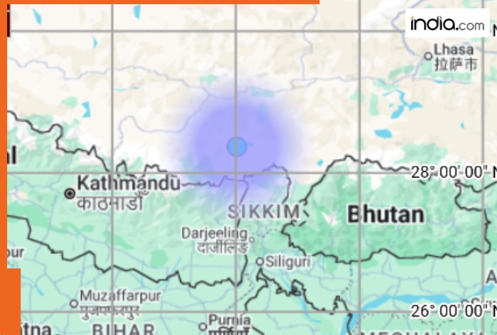
Tibet: An earthquake of 3.0 magnitude on the Richter scale struck Tibet on Saturday. According to National Center for Seismology (NCS), the quake’s depth was 10 km. The NCS took to X and informed that “EQ of M: 3.0, On: 24/01/2026 03:40:55 IST, Lat: 28.37 N, Long: 88.02 E, Depth: 10 Km, Location: Tibet.”
An earthquake of 4.3 magnitude on the Richter scale struck Tibet on Wednesday, a statement by the National Center for Seismology (NCS) said. The earthquake occurred at a depth of 90km. In a post on X, the NCS said, “EQ of M: 4.3, On: 14/01/2026 12:27:41 IST, Lat: 27.96 N, Long: 87.87 E, Depth: 90 Km, Location: Tibet.”
It was the second earthquake in the region within 10 days. On January 24, a quake of magnitude 4.3 struck Tibet. The depth of the quake was 90 km.
EQ of M: 3.0, On: 24/01/2026 03:40:55 IST, Lat: 28.37 N, Long: 88.02 E, Depth: 10 Km, Location: Tibet.
For more information Download the BhooKamp App https://t.co/5gCOtjdtw0 @DrJitendraSingh @OfficeOfDrJS @Ravi_MoES @Dr_Mishra1966 @ndmaindia pic.twitter.com/EsqIs2sGcy— National Center for Seismology (@NCS_Earthquake) January 23, 2026
Also Read: EARTHQUAKE of 5.7 magnitude hits Leh Ladakh, govt issues advisory
Shallow earthquakes are generally more dangerous than deep earthquakes. This is because the seismic waves from shallow earthquakes have a shorter distance to travel to the surface, resulting in stronger ground shaking and potentially more damage to structures and greater casualties.
The Tibetan Plateau is known for its seismic activity due to tectonic plate collisions.
Tibet and Nepal lie on a major geological fault line where the India(BHARAT)n tectonic plate pushes up into the Eurasian plate, and earthquakes are a regular occurrence as a result of it. The region is seismically active due to tectonic uplift that can become sufficiently strong to alter the elevations of the Himalayan peaks.
The Tibetan Plateau attains its high elevation due to crustal thickening caused by the collision of the India(BHARAT)n and Eurasian plates, which created the Himalayas. Faulting within the plateau is associated with strike-slip and normal mechanisms. The plateau extends east-west, as evidenced by north-south-striking grabens, strike-slip faulting, and GPS data.
In the northern region, strike-slip faulting constitutes the dominant style of tectonics, while in the south, the dominant tectonic domain is east-west extension on north-south trending normal faults.
Seven rifts and normal faults running north to south in southern Tibet were found through satellite images in 1970s and early 1980s. They started forming 4 to 8 million years ago as the region started to stretch.
(With ANI Inputs)
What's Your Reaction?