


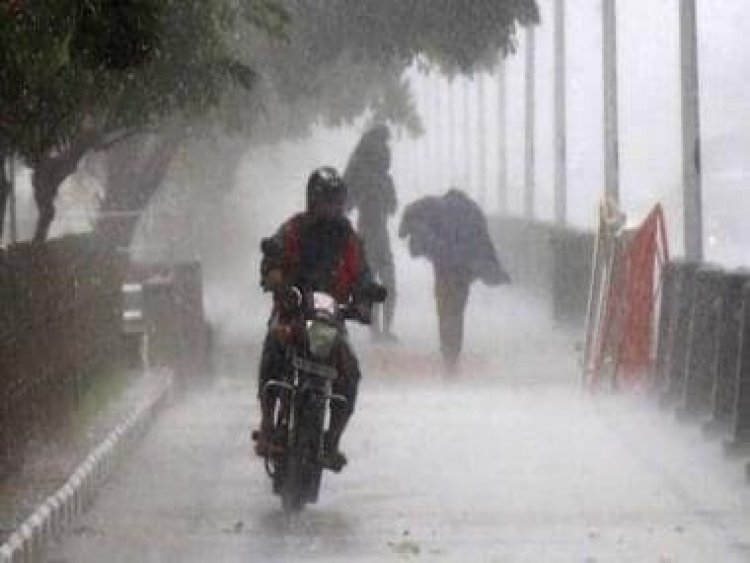
The Weather Report: Central and North India set for heavy rains as monsoon makes quick revival
The Weather Report: Central and North India set for heavy rains as monsoon makes quick revival
The presence of rains was restricted to parts of south India over the past week as the presence of shear zone and wind discontinuity has prevailed leading to large scale moisture incursion.
Continuous spells of heavy rains were observed in many parts of Karnataka, Kerala, Tamil Nadu, Telangana and Andhra Pradesh. The routine spells of heavy rains resulted in floods in the urban areas where Bangalore was most affected.
The incessant downpour led to record breaking rains in the Silicon Valley of India. For the first time the India’s Meteorological observatory recorded 1,030mm rainfall in the Southwest monsoon season till 8:30 pm on 6 September since 1 June against an average of 597.7 mm for the entire season. In the past rainfall has never crossed 1,000mm mark during Southwest monsoon.
Similarly, another observatory which is at Hindustan Aeronautics Limited Airport commonly known as HAL has received 1,466.6 mm rains for the year making it the wettest annual figure since the creation of the observatory and record keeping began in 1947 breaking the previous record of 1,426mm from 2005.
The rains have also made a strong comeback in Mumbai in the past week this time with thunderstorms, multiple events of lightning strikes and heavy rains have been observed in Mumbai and neighbouring areas.
Rainfall ending 8:30am on 8 September:
Kalyan — 129mm
Ambivli — 126mm
Thane — 111mm
Dombivli — 102mm
Airoli — 92mm
Badlapur — 88mm
Turbhe — 86mm
Bhandup — 84mm
Nerul — 82mm
Ulhasnagar — 80mm
Mumbra — 77mm
Sanpada — 74mm
Mulund — 74mm
Belapur — 68mm
Powai — 68mm
The intensity of rains and thunderstorms have increased further, heavy to very heavy rains have been observed in multiple areas of the city as the data ending 8:30am on 9 September suggests.
Kalyan — 141 mm
Ambivli — 137mm
Thane — 125mm
Mulund — 123mm
Dombivli — 113mm
Airoli — 114mm
Badlapur — 109mm
Turbhe — 105mm
Bhandup — 102mm
Kandivali — 99mm
Borivali — 97mm
Nerul — 93mm
Prolonged spell of monsoon break is leading to dry and hot weather across the plains of North India especially in Rajasthan where weather is completely dry for more than a fortnight now.
Farmers in the region are facing the brunt of the unusual September heat as the kharif crop ripening is way early and due to higher than normal temperature by 3 to 4°C, crops are also burning. Kharif might turn out to be a low production season for the farmers in North India.
In the past week maximum temperatures have also crossed 40°C mark at a couple of observatories.
On Friday Churu in Rajasthan recorded 41.0°c maximum temperature. The maximum temperature at some more stations of Rajasthan are:
Jaisalmer — 40.5°C
Bikaner — 40.1°C
Barmer — 39.4°C
Nagaur — 38.7°c
Jalore — 38.6°C
Jodhpur — 38.5°C
Alwar — 38.2°C
Karauli — 38.1°C
On Saturday, Phalodi in Rajasthan observed heatwave as the station recorded 41.6°C maximum temperature which is 5°C above normal matching the criteria for heatwave declaration which is realised maximum temperature should be 40°C or above and its departure from normal should be +4.5°C or above.
Higher than normal maximum temperatures were observed in few more stations of Rajasthan on 10 September:
Jaislamer — 40.8°C
Bikaner — 40.5°C
Barmer — 39.4°C
Ganganagar — 38.6°C
Jodhpur — 38.5°C
Churu — 38.4°C
The other parts of the plains are now influenced by the easterly winds reaching out due to the formation of the depression off the Odisha coast, the maximum temperatures have fell by 2-3°C in stations of Uttar Pradesh, Delhi NCR, Haryana, Punjab but real feel is still close to 45-48°C due to higher humidity levels.
Maximum temperature on Saturday in other parts of plains:
Delhi — 36.8°C
Hisar — 36.8°C
Rohtak — 35.9°C
Chandigarh — 35.1°C
Lucknow — 35.0°c
As per IMD data, total monsoon seasonal rains in India from 1 June till 11 September:
• India as a whole recorded a total of 801.5mm rainfall against the average of 766.6mm, a departure from normal Stands at +5 per cent, it was at +5 per cent past Saturday as well – heavy rains in the peninsula and West India kept the change on hold.
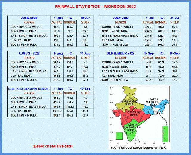
Subdivision wise seasonal rainfall figures:
• Southern Peninsula: Actual 802.4mm against the average of 605.9mm, +32% departure from normal.
• East and North East India: Actual 968.2mm against the average of 1182.4mm, -18 per cent departure from normal.
• North West India: Actual 496.7mm against the average of 534.2mm, -7 per cent departure from normal.
• Central India: Actual 1000.2mm against the average of 875.8mm, +14 per cent departure from normal.
Current synoptic features influencing weather in India as on 11 September:
• The Well-Marked Low Pressure Area over West Central and adjoining Northwest Bay of Bengal off north Andhra Pradesh-south Odisha coasts moved west-northwestwards and concentrated into a Depression and lay centered at 0530 hrs IST of today, the 11th Sept 2022, over south coastal Odisha and neighbourhood near latitude 19.5°N and longitude 84.7°E, about 20 km northwest of Gopalpur. It is likely to move west-northwestwards across south Odisha and south Chhattisgarh during next 24 hours and weaken gradually.
• The monsoon trough at mean sea level now passes through Nalia, Ahmadabad, Akola, Ramgundam, the centre of Depression over south coastal Odisha and neighbourhood and hence east-southeast wards to East Central Bay of Bengal.
• A cyclonic circulation lies over East Central Arabian Sea off south Maharashtra-Goa coasts and extends upto 1.5 km above mean sea level.
•The shear zone now runs roughly along Lat.16°N over South Peninsular India between 3.1 km & 7.6 km above mean sea level.
• Yesterday’s trough from east central Arabian Sea off Konkan coast to the Well-Marked Low Pressure Area over West Central & adjoining Northwest Bay of Bengal off north Andhra Pradesh-south Odisha coasts across Maharashtra, Telangana, south Chhattisgarh and coastal Andhra Pradesh extending upto 1.5 km above mean sea level has become less marked.
All India Weather Forecast till 17 September:
North India
The dry phase of weather might start fading away over the next week since the easterlies have pushed in from the Bay of Bengal towards North India.
Parts of Uttarakhand and Himachal Pradesh have already started receiving moderate to heavy rains on the weekend.
Since the monsoon axis is expected to stay south of its normal position and only Easterlies are expected to influence and bring a lot of moisture content in the plains. Isolated to scattered moderate rains will comeback in Uttar Pradesh, Haryana, Punjab, Delhi NCR and Rajasthan between 11 to 14 September, the spread of rains will be lesser hence discomfortable sultry weather is likely to prevail.
As the depression off the Odisha coast move inland towards Central parts of the country convergence will increase in the northern parts of the country leading from heavy to very heavy rains in Uttar Pradesh, Uttarakhand, Himachal Pradesh, South East Rajasthan during 14 to 16 September. Meanwhile spread of rains and intensity might increase slightly in parts of Punjab, Haryana, Jammu, Delhi NCR at the same time and the upcoming week might end on a slightly wetter note compared to the last two weeks.
The rainy spell towards the end of the week may even lead to fall in maximum and minimum temperatures by a couple of degrees bringing in slight respite from the unusual September heat.
Expected precipitation accumulation till 17 September:
• Uttarakhand — 120mm
• Himachal Pradesh — 100mm
• Uttar Pradesh — 90mm
• Jammu and Kashmir — 70mm
• Delhi NCR — 40mm
• Haryana — 40mm
• Punjab — 30mm
• Rajasthan — 30mm
Central India
The Monsoon revival over central India is expected to be quick one during the upcoming week, the depression from the Bay of Bengal is expected to move West upto Madhya Pradesh and become bit stationery due to the upcoming westerly trough.
Under such situations widespread heavy to very heavy rains occur over central parts of the country as depression along with the monsoon axis are the main players on the rains.
Across the upcoming week most parts of Chhattisgarh, Madhya Pradesh, Gujarat and Maharashtra to experience prolonged spell of heavy rains, after a very wet August and quick revival of monsoon with humongous rains may open scope of flooding in central parts of India again.
Expected Precipitation accumulation till 17 September:
• Maharashtra — 180mm
• Chhattisgarh — 160mm
• Madhya Pradesh — 140mm
• Gujarat — 140mm
East and North East India
The axis of monsoon has shifted south and foothills of Himalayas along with the North East India is out of its influence now leading to decrease in rainfall activities over the states.
Meanwhile the formation of depression off the south Odisha coast will play a very crucial role in bringing good rains in the drought-hit Indo Gangetic plains.
The depression is expected to move West but the convergence and southerly moist winds from Bay of Bengal will impact the weather of East India across this week.
Extremely heavy rains are expected in parts of West Bengal and Odisha during 11 to 14 September whereas many parts of Jharkhand and Bihar may experience heavy to very heavy rains, hopefully it is going to be the first widespread rainy week of the season in the east India and rainfall deficiencies might come down by a bit.
Meanwhile parts of Arunachal Pradesh, Assam, Meghalaya, Mizoram, Nagaland, Tripura, Manipur to experience scattered light to moderate rains during the entire week.
Expected Precipitation accumulation till 17th September:
• West Bengal — 240mm
• Odisha — 170mm
• Jharkhand — 130mm
• Bihar — 90mm
• North East India — 70mm
Southern Peninsula
The shear zone over states of south India is expected to move northwards during the next two days and the wind discontinuity is likely to fade away from the interiors.
This will lead to a major reduction in the rainfall activities over Tamil Nadu, South interiors of Karnataka including Bangalore and Kerala, the flood hit parts of the region to get some respite this week as no major rains are expected.
Somehow due to the formation of depression and pull effect the offshore trough will strengthen this week. The impact will be observed in most parts of the West coast and Ghat sections of Goa and Karnataka where prolonged spells of heavy rains will be observed during the entire course of the week.
Parts of North Andhra Pradesh and Telangana to experience good rains due to the influence of the tropical depression during the beginning of the week.
Expected precipitation accumulation till 17 September:
• Goa — 190mm
• Karnataka — 130mm
• Kerala — 90mm
• Telangana — 70mm
• Andhra Pradesh — 60mm
• Tamil Nadu — 20mm
The author, better known as the Rohtak Weatherman, interprets and explains complex weather patterns. His impact-based forecasts @navdeepdahiya55 are very popular in north India.
Read all the Latest News, Trending News, Cricket News, Bollywood News,
India News and Entertainment News here. Follow us on Facebook, Twitter and Instagram.
What's Your Reaction?


