


The weather report: South India witnesses rainy week as North East monsoon advances
The weather report: South India witnesses rainy week as North East monsoon advances
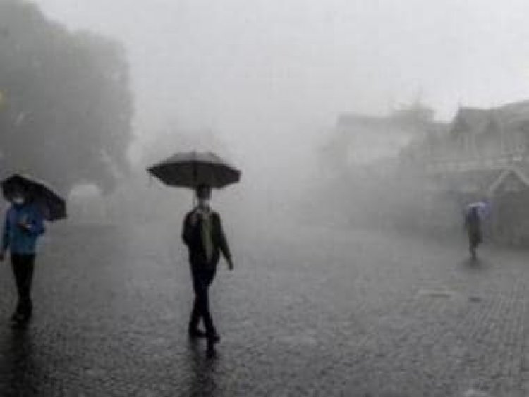
It’s been a rainy week in the southern parts of the country specially in Tamil Nadu, Kerala and South Andhra Pradesh as the North East monsoon advanced in the region with a bang.
Parts of Chennai had already achieved 70% of seasonal rainfall within the span of a week and at the beginning of the rainy season itself.
Many parts of Chennai crossed 200mm rainfall accumulation while some stations received rains above 300mm during the period of 31st October till 3rd November:
George Town: 338.6mm
Perambur: 307.8mm
Anna Nagar: 275.8mm
Ambattur: 272.5mm
Mugappair: 271.7mm
Red hills: 269.0mm
Nungambakkam: 267.0mm
Ponneri: 260mm
Indira Nagar: 244.0mm
Ayanavaram: 240.1mm
Ponmar: 230.0mm
Royapettah: 229.4mm
Mylapore: 229.0mm
Mambalam: 224.6mm
Avadi: 218.0mm
Kk Nagar: 215.9mm
Perumbakkam: 212.1mm
Saidapet: 210mm
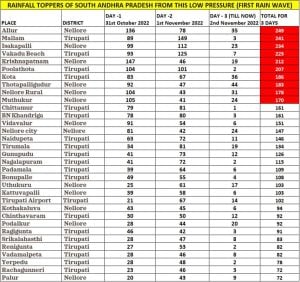
Credits for the very heavy spell of rain goes to the low pressure area that originated in Bay of Bengal next to the Tamil Nadu coast, at the same time many parts of South Andhra Pradesh received heavy to very heavy rains, stations mainly from Nellore and Tirupati district have also crossed 200mm rainfall accumulation in the period of just 3 days:
Allure: 249mm
Mallam: 241mm
Isakapalli: 234mm
Vakadu beach: 225mm
Krishnapatnam: 212mm
Poolathota: 207mm
Most states in Central and East India continue to observe dry weather in the past week, temperatures wise prevailing conditions are pleasant but transition towards winter is yet to start as maximum temperatures are around 32 to 35°c at most places meanwhile minimum have started dipping below 20°c in Maharashtra, Telangana, Chhattisgarh, Odisha, Madhya Pradesh, Gujarat, Jharkhand, West Bengal, Bihar.
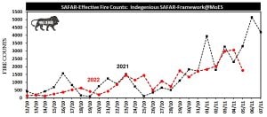
Meteorological conditions have remained highly stable across north India post the withdrawal of monsoon and in the last week as well due to the formation of an anti-cyclonic circulation over the Rajasthan, the calmness in the atmosphere lead to a major pollution outbreak across the plains as emissions from all the source found no space to transport amid wind speed was negligible in the mid week.
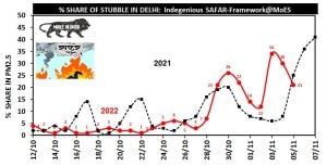
The Air quality index in many parts of Delhi NCR moved to the severe category, Share contribution of stubble burning has also increased up to 34% around 3rd November as a result air quality deteriorated along with the pollution from various other urban sources.
Saturday onwards a western disturbance approached Himalayas, under the influence the wind direction has changed from westerly to easterly also the wind speed increased significantly leading to improvement in the air quality index and decrease the layer of smog from the atmosphere still the air quality maintains the very poor category on Sunday.
Interestingly as the winds have changed direction to easterlies temperatures started rising across the west and north India, Just before the western disturbance arrived a short spell of unusual record breaking November heat is observed in parts of Gujarat and Rajasthan.
Bhuj in Gujarat recorded 39.2°C maximum temperature on 4th November and broke the all-time record of the month, Previous record was set on 1st November, 2009 with 39.0°C maximum temperature.
Churu in Rajasthan at 37.8°C maximum temperature on 4th November , matched its monthly all-time record from 1st November 1999.
Barmer recorded 38.7°C on 4th November, second highest maximum temperature since 1979, All time record is 38.8°C from 1st November 1979.
Jaisalmer reported 38.5°C on 3rd & 4th November and had a close date with the all-time record of 38.8°C from 12th November 1990.
Pilani reported 37.5°C on 5th November, Closely missed the all- time record of 37.8°C from 2nd November 1977.
Under the influence of the western disturbance rainfall recorded in Jammu and Kashmir till Sunday morning:
Srinagar: 26.1mm
Shalimar: 29.0mm
Qazigund: 16.0mm
Pahalgam: 14.3mm
Kupwara :16.2mm
Kokernag :11.4mm
Gulmarg :16.8mm
Pampore : 20.5mm
Srinagar Airport :28.2mm
Awantipora: 21.8mm
Anantnag: 15.0mm
Khudwani: 15.0mm
Budgam: 21.0mm
Baramulla: 23.5mm
Bandipora: 22.0mm
Shopian: 10.0mm
Kulgam: 21.0mm
Jammu: 16.2mm
R S Pura: 6.5mm
Banihal: 24.8mm
Batote: 17.9mm
Katra: 17.0mm
Bhaderwah: 13.2mm
Kathua: 10.2mm
Rajhani: 7.5mm
Burmal: 7.5mm
Jammu Airport: 4.4mm
Udhampur: 36.8mm
Ramban: 15.0mm
Kawa: 4.0mm
Poonch: 51.0mm
Kishtwar: 16.0mm
Reasi: 24.5mm
Samba: 5.0mm
Chatha: 11.5mm
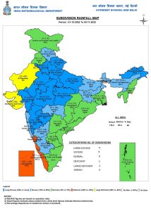
Rainfall performance in the post Monsoon season so far is in above normal category across the country as India as whole recorded a total rainfall of 116.8mm against the normal of 83.6mm in the period of 1st to 6th November, the departure from normal stands at +40% falls from +52% from last Sunday as only south India is leading the rainfall numbers, rest parts of the country have majorly stayed dry.
Subdivision wise seasonal rainfall figures
• Southern Peninsula: Actual 193.5mm against the average of 179.5mm, +8% departure from normal.
• East & North East India: Actual 164.6mm against the average of 130.0mm, +27% departure from normal.
• North West India: Actual 68.5mm against the average of 24.0mm, +185% departure from normal.
• Central India: Actual 93.5mm against the average of 60.1mm, +56% departure from normal.
Current synoptic features influencing the weather in India as on 6th November:
• The cyclonic circulation over Southeast Bay of Bengal & adjoining Equatorial Indian Ocean
extending upto 1.5 km above mean sea level persists.
• The east-west trough from Comorin area to above cyclonic circulation over Southeast Bay of Bengal
& adjoining Equatorial Indian Ocean across South Bay of Bengal extending upto 1.5 km above mean
sea level persists.
• The Western Disturbance is a trough in westerlies with its axis at 5.8 km above mean sea level
roughly along Long. 60°E to the north of Lat. 30°N persists.
• The cyclonic circulation over Haryana & neighbourhood extending upto 1.5 km above mean sea level
persists.
• A Low Pressure area is likely to form over southwest Bay of Bengal off Sri Lanka coast around 09th
November, 2022. It is very likely to move northwestwards towards Tamilnadu-Puducherry coasts with
possible intensification during subsequent 48 hours.
All India weather forecast till 13th November:
South India:
Subdued rainfall activities are expected in Tamil Nadu, Kerala over the next couple of days whereas dry weather is expected in Andhra Pradesh, Telangana, Karnataka and Goa till mid week.
Weather models ensembles continue to hint for a formation of a low pressure area in the South bay of bengal by Wednesday, under the influence once again coastal Tamil Nadu stretch between Chidambaram and Chennai remain vulnerable for heavy rains later this week with many places likely to record around 150-200mm with isolated places are projected to record as high as 350 to 400mm rains by the weekend.
High chances for Chennai and adjoining areas to once again experience very heavy rainfall spells.
Similar to the previous spells moderate to heavy rains will reach interiors of South Andhra Pradesh, South Karnataka, Bangalore and across Kerala between 11th to 13th November.
North India:
A Western Disturbance is already impacting weather over the western Himalayas on the weekend bringing fresh snowfall over the hill stations, meanwhile states in the plains have not been impacted by any kind of precipitation so far.
In a quick succession another moderate Western Disturbance is predicted to approach the western Himalayas by 9th November under the influence many parts of Kashmir, Himachal Pradesh, Uttarakhand to record moderate rains on the lower levels while hill tops and higher reaches will record fresh moderate snowfall with temperatures mainly at sub zeros.
As soon the western disturbance reaches Himalayas – Easterlies will be blowing in the plains along with the formation of the cyclonic circulation around Punjab – light to moderate rains are expected in some parts of Punjab, Haryana, Delhi NCR, North Rajasthan and Western Uttar Pradesh during 9th and 10th November.
Maximum temperature is expected to fall by 3 to 4°c due to enhanced cloudiness and rains, also the air quality index might improve slightly as rains move in the region for the first time in the month of November so far.
Post the rainy spell both minimum and maximum temperature will start dropping across the north India weekend onwards as we head towards mid November winter feel is to set in.
As there is no significant weather system to impact India’s North East, West Bengal, Bihar, Jharkhand, Odisha, Chhattisgarh, Madhya Pradesh, Maharashtra, Gujarat – dry weather conditions will prevail in these states across the upcoming week however the temperatures will stay in a pleasant range.
The author, better known as the Rohtak Weatherman, interprets and explains complex weather patterns. His impact-based forecasts @navdeepdahiya55 are very popular in north India.
Read all the Latest News, Trending News, Cricket News, Bollywood News,
India News and Entertainment News here. Follow us on Facebook, Twitter and Instagram.
What's Your Reaction?


